Jammu - the Duggar land where the past still has a living presence. A land of grand ancient temples, and beautiful palaces. Nestled against the backdrop of the snow-capped Pir Panjal Mountains, the region of Jammu constitutes the southernmost unit of the state of Jammu & Kashmir. It forms part of the transition between the Himalayan range in the north and the dusty plains of Punjab in the south. Between these two extremities lie a series of scrub-covered hills, forested mountain ranges and river valleys, encompassing several microclimatic regions that extend from Kishtawar in the north-east to Akhnoor in the south-west, and the historic town of Poonch in the north-west to the borders of Kangra (H P) in the south-east. The Shivalik hills cut across the area from the east to the west while the rivers Ravi, Tawi and Chenab cut their way through the region.
This museum is housed in the Amar Mahal Palace, built in 1862 in a unique, French-chateau style of architecture. Located atop a hill overlooking the Tawi river, 4 rooms of the palace have been converted into art galleries and historic museums, depicting the royal history of Jammu. The star of this museum is the golden throne of Jammu, weighing a whopping 120 kgs, all pure gold. The art collection here is also quite impressive, with paintings of M F Hussain and Laxman Pai on display, among other famous Indian contemporary painters. Another interesting aspect is the Pahari Paintings displayed here, depicting tales from the Mahabharata and other folklore, especially those of Nal Damyanti. The museum also organises heritage walks around the complex to give detailed insights into the history of Jammu and surrounding cities.
Situated 5 kms away from the city centre, Bahu Fort stands on a rock face on the left bank of the river Tawi. Perhaps the oldest fort and edifice in the city, it was constructed originally by Raja Bahulochan over 3,000 years ago. The existing fort was more recently improved upon and extended by the Dogra rulers. Inside, there is a temple dedicated to the Hindu goddess Kali. An extensive terraced garden, known as Bagh-e-Bahu, has been developed around the fort. The fort, along with the Bahu temple, commands a panoramic view of the Jammu city. On the bypass road, behind the Bahu fort, the city forest surrounds the ancient Maha Maya Temple overlooking the River Tawi. A small garden surrounded by acres of woods furnishes a populated destination for tourists. Mahamaya is the local goddess of the Dogras, who lost her life 14 centuries ago combating foreign invaders.The subcontinent's largest underground aquarium in Jammu's Bagh-I-Bahu area is drawing a large number of tourists ever since it was opened to the public.Besides students, the aquarium has become a centre of attraction for tourists, giving them an opportunity to revel in the exotic aquatic world. The aquarium has attracted large number of tourists visiting the State.
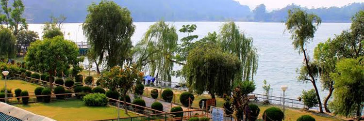
The Mansar lake near Jammu city is one of the most famous adventure tourism destinations in India. Mansrover, is also called as Mansar. The Mansar lake is about 20 km from National Highway No. 1A. Road to Mansar Lake starts from just near Samba on National Highway No. 1A. The shortcut road from Mansrover or Samba to Udhampur by-pass the Jammu town. Mansar lake, with its length more than a mile and width half-a-mile, is a very attractive lake in the midst of lusting greeneries surrounded by forest-covered hills. It is considered as a very holy site known from mythological periods sharing the sanctity and legacy of Mansa Sarovar. It is a very popular base of tourists. A temple for a snake god, Sheshnag, is located on the banks of lake. It is believed that it is auspicious for newly wed couples to seek blessings of Sheshnag by performing three parikarma around the lake.
"Purmandal" is a holy place located in Jammu District, Jammu and Kashmir. It is about 30 km to the east of Jammu. It is also referred as 'Chhota Kashi'. Purmandal is situated on the banks of the Devika River, was an ancient center of trade and learning.The prime attraction is the Purmandal Temple which is dedicated to 'Umapati' (Goddess Parvati). There are a number of temples built on rocks dedicated to Lord Shiva which presents an imposing sight. The significance of these temples and dharamshalas lies in the frescoes on their walls.

Jhajjar Kotli is a famous picnic spot and tourist complex in the state of jammu and Kashmir built on the banks of the rivulet named Jujjar and approx 27 km from jammu on the national highway that leads toward the city of Srinagar. The main attraction of this beautiful tourist place is the clear and refreshing cool water of Jujjar. and its surrounding natural beauty. This place is wholly owned by the Jammu and Kashmir Tourism Development Corporation. To facilitate the tourists there is a wonderful tourist bungalow in Jhajjar Kotli maintained by the department of tourism. The Jhajjar Kotli tourist complex receives a large number of tourist and visitors during the summer months.
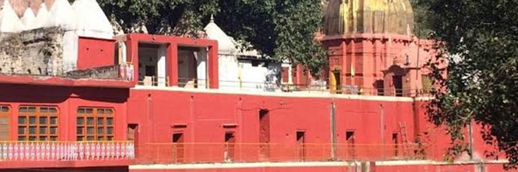
Raghunath Temple, with seven shrines each with its own `Shikhara`, (shikhara, a Sanskrit word translating literally to `mountain peak`, refers to the rising tower in the Hindu temple architecture in north India) is one of the largest temple complexes of north India, located in Jammu city. Maharaja Gulab Singh and his son Maharaj Ranbir Singh built the temple, during the period of 1853-1860. The temple has many gods enshrined, but the presiding deity is Lord Ram, an `avatar` (incarnation) of Lord Vishnu.Glimpses of Mughal masonry can be visualised in the architectural splendor of Raghunath Temple. The carvings and arches being extraordinarily resplendent, grabs everyone`s attention. There is a library in the temple complex, housing rare Sanskrit books and manuscripts. People visit this temple in large numbers to pay their homage to the deity and seek blessings from the Lord.
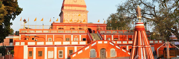
The biggest Shiva temple in north India, Ranbireshwar Temple is one of the prime attractions in the picturesque Jammu city. It is a very ancient shrine, located in Shalimar Road near the New Secretariat. Maharaja Ranbir Singh built it in 1883, dedicated to Lord Shiva.The temple has a central `lingam` measuring 8-feet in height, constructed out of black stone, is the biggest in India. It was under the built of the Dogra rulers; also enshrining 12 shivlings in crystal, measuring 15cm to 38cm. Galleries with 1.25 lakh `bona lingam` brought from Narmada River, can be witnessed on stone slabs inside the temple. There are also mammoth images of Ganesha, Kartikeya and Nandi Bull.
Mahamaya Temple is an important site dedicated to a local female freedom fighter, Mahamaya, belonging to the Dogra community. According to historians, about 14 centuries ago, Mahamaya sacrificed her life to save the region from the clutches of foreign invaders. This site is situated on the banks of the Tawi River, where from, tourists can easily sight the Bahu Fort.According to popular legend, about fourteen centuries ago, she opposed the foreign attackers and valiantly confronted them. People honor her sacrifice and eulogize her to this day. Her courageous resistance is now a part of the glorious myth of Jammu. And hence not surprisingly an entire temple is dedicated in her honor. Mahamaya Temple in Jammu is one such temple which is flocked by devotees who come to offer their prayers.
It is situated near Samba and is popularly known as Pehla Darshan of Vaishno Devi pilgrims. One of the prominent religious sites of Jammu and Kashmir, Chichi Mata is generally believed to be the gateway to the temple of Vaishno Devi. Commonly said to be the Pehla Darshan of the pilgrims of Vaishno Devi, Chichi Mata commands an important position in the religious ancestry of the state.A prominent itinerary of the Jammu and Kashmir pilgrim tourism, Chichi Mata draws numerous devotees from far and wide. The visit to the holy shrine of Vaishno Devi is incomplete without the visit to the famous religious monument ofChichi Mata. Thronged by ardent pilgrims of the Hindu religion, Chichi Mata temple authorities observes strict religious rituals as per the traditional customs.One must visit the holy shrine of Chichi Mata on his or her way to Vaishno Devi temple. Devoted to Goddess Vaishno Devi, the well known religious site of Vaishno Devi temple attracts several tourists who make it a point to pay a visit to the divine shrine of Chichi Mata.
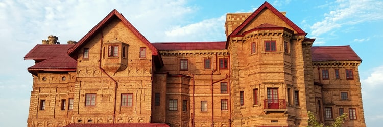
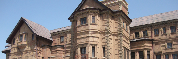
Built over a span of 150 years, this royal building served as a massive palace for rulers of the Dogra dynasty. It was infact the main seat of the kingdom until 1925, after which Raja Hari Singh moved the royal seat to Hari Niwas Palace in Northern Jammu. Prone to earthquakes and fires, parts of this building, like the Gol Ghar, lie now in ruins, adding to the palace's old world charm.The Pink Hall inside the palace has now been converted to a museum that holds several miniature paintings and emperor Shah Jahan's golden bow and arrow, among other interesting things. The architecture of the palace is borrowed from European Baroque, Mughal and Rajasthani styles, bringing forth a unique blend of different cultures, that adds a distinct character to both the palace and Jammu.
Katra, also known as Katra Vaishno Devi, is a city in the Reasi district of the state of Jammu and Kashmir in India. It is in the foothills of the Trikuta Mountains, about 42 km from the city of Jammu, and 35 km from Udhampur. The main attraction is the Maa Vaishno Devi temple.
Bhaderwah is a town in Doda district of Jammu and Kashmir state. Bhaderwah valley is predominantly a mountainous town situated 80 km from Batote. Bhadarwah is located on the foothills of middle Himalayas. The town is endowed with breath-taking natural beauty which is why it is popularly called "Mini Kashmir".
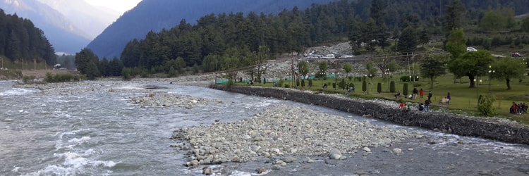
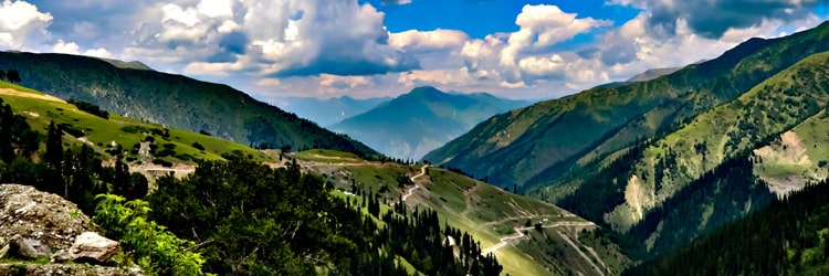
Kashmir - the "Paradise on Earth", is known for its captivating beauty. It is encircled by three mountain ranges of the Himalayas- Karakoram, Zanaskar and Pir Panjal, running from northwest to northeast. Forming the backdrop of Kashmir, these snow-capped ranges make Kashmir look like a picture straight out of a fairytale. Dazzling rivers, serene lakes, splendid gardens, flowering meadows, etc are some other features of the landscape of the Kashmir valley. The breathtaking beauty of Kashmir has earned it the name of the "Switzerland of the East". Nothing describes the beauty of Kashmir better than the following words of a Mughal emperor: "Gar Bar-ru-e-Zamin Ast; Hamin Ast, Hamin Ast Hamin Ast." It means that if there is paradise on this earth, this is it, this is it, and this is it. It is impossible to overstate the beauty of Kashmir. The gushing rivers, sparkling waterfalls, scenic surrounding and the lush green forests of Kashmir add to its splendor. Kashmir tourism is also famous for the exotic flora and fauna found in the region. The sanctuaries and parks in Kashmir abound in some of the rare and endangered species of birds and animals. Then, there are countless species of luxuriant vegetation too, attracting a number of botanists.
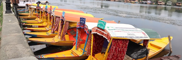
Srinagar, the state's winter capital, is the first stop for most travellers to Kashmir; and with its great lake and meandering river, its exquisite pleasure gardens and romantic shikara rides, the old-world charm of its houseboats and the ageless grace of its architecture, the city is a fitting introduction to the many enchantments of the valley. The vast Dal lake is, of course, Srinagar's emblematic feature, and its deep waters carry the most popular of Srinagar's attractions: houseboats and shikaras. Many visitors are content to spend a great part of their holiday aboard these waterborne hotels, watching the lake's traffic float by from cushioned balconies, venturing into the houseboat's walnut-wood interiors for delicious, fragrant Kashmiri cuisine.Main Tourist Spots In Srinagar Are:
Dal Lake
Nageen Lake
Shalimar Bagh
Nishat Bagh
Chashma Shahi
Gulmarg's legendary beauty, prime location and proximity to Srinagar naturally make it one of Asia's premier hill resorts. Originally called 'Gaurimarg' by shepherds, Gulmarg was discovered in the 16th century by Sultan Yusuf Shah, who was inspired by the sight of its grassy slopes emblazoned with wild flowers. It was also a favourite resort of the Mughal Emperor Jahangir. Today, Gulmarg is not merely a mountain resort of exceptional beauty but also the country's premier ski resort in winter when it is covered in snow and takes on the appearance of a picture postcard.Gulmarg was first established as a ski resort by the British who had set up the Ski Club of India here in 1927. Skiing at Gulmarg had become very popular during the pre-independence years. The resort used to host two major skiing events, one each during Christmas and Easter. In 1938-39, about 500 skiers are said to have participated in Christmas and Easter ski races. Gulmarg's atmosphere was identified with European ski resorts of the 1940's and 50's - the 'Alps of good old days'. It has good sunshine as well as good snow.
Around Pahalgam are many places of interest, and the most beautiful of these is the huge, undulating meadow of Baisaran, surrounded by thickly wooded forests of pine. "Betaab Valley", on the way to Chandanwari, is an idyllic spot for a picnic. Filmgoers will recognize it instantly as it has been the location of several movie scenes. Aru, 12 kms from Pahalgam, is a picturesque meadow and base point for trekking to Kolhai glacier, Katar Nag, Lidder Watt and Trasar & Marsar Lakes.
"Sonamarg in the Kashmir valley is the gateway to Ladakh and situated just before the Zojii La pass. Located at 87 km from Srinagar, the place is renowned for trekking and hiking trails. The snow clad peaks in the Himalaya and the undulated hilly mountainous regions are perfectly suitable for all types of trekking expeditions. Sonamarg is the base camp for many trekking expeditions. The major treks passing through various mountain lakes such as Gangabal, Vishansar, Gadsar, Satsar and Kishansar has its base at Sonamarg. The trekking routes offer all types of challenges, from mild to most hard. The pleasant climate with mild summer and cold winter make this place an ideal location for trekkers to explore the natural beauty and challenging treks.

Yousmarg (a meadow), mesmerizes tourists with its scenic beauty and mountains comparable to European Alps. Situated amidst Sang Safed valley, Yousmarg is reputed for having some unique spring flowers. It also has some of the highest peaks in PirPanjal range like Tatakoti 4725 mtrs and Sunset Peak 4746 mtrs. The mighty river Doodh Ganga makes this destination more thrilling. The natural slopes of Yousmarg offer skiing opportunities to experts. Last few years of large inflow of tourists into Kashmir valley has seen the diversification of tourism to this wonderful destination.
Verinag is situated at a distance of approximately 80 km from Srinagar. Reached through the link road, it is located at a height of 1,876 m. It is believed that the Verinag spring in Kashmir is the chief source of the river Jhelum. There is an octagonal base at the spring, surrounded by a covered passage. The Mughal Emperor Jehangir started the construction work on both the base as well as the arcade. It was during the reign of Emperor Shah Jahan that the work got completed. There are remains of Mughal pavilion and baths in Verinag , down the stream to the east. The Verinag Spring, named after Nila Nag, the son of the famous Hindu sage Kashyap Rishi, to whom, goes the credit of establishing the territory of Jammu and Kashmir is one of the principle tourist attractions of a tour to Verinag .
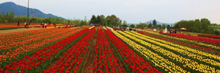
Indira Gandhi Memorial Tulip garden, previously Model Floriculture Center, is a tulip garden in Srinagar, Kashmir. It is the largest tulip garden in Asia spread over an area of about 30 hectares. It is situated on the foothills of Zabarwan Range with an overview of Dal Lake. The garden was opened in 2007 with the aim to boost floriculture and tourism in Kashmir Valley. The garden is built on a sloping ground in a terraced fashion consisting of seven terraces. Apart from tulips, many other species of flowers - hyacinths, daffodils and ranunculus have been added as well.
Dodhpathari is a bow- shaped valley about 42 kms form Srinagar. It is a recent discovery in the valley covered with green carpeted meadows. An adjoining river resounds the soft wind passing through pine trees of the surrounding forests. It is said that the cattle grazing in the meadows of Dodhpather, produces rich milk in large quantity, and for this reason it is also called the "valley of milk". Shepherds from different areas travel to this place along with their cattle's and stay there for days together. This area also connected to Gurez valley on its north. A cup of tea with snack at tea stalls run by local people during the season at the main meadows could become your most pleasurable drink. A full day tour to Dodhpather with some packed lunch will definitely be a bonus to your visit to Kashmir.
Gurez is a valley located in the high Himalayas, about 86 kms from Bandipore and 123 kms from Srinagar in northern Jammu and Kashmir, India. At about 8,000 feet (2,400 m) above sea level, the valley is surrounded by snow capped mountains. It has diverse fauna and wildlife including the Himalayan brown bear and the snow leopard. The Kishanganga River flows through the valley. The road to Gilgit runs through Gurez. Gurez is divided into three regions. The area from Toabat to Sharda Peeth is administered by Pakistan as Neelum District, that between Kamri and Minimarg is part of the Astore District, Northern Areas, Pakistan, and that from Toabat to Abdullae Tulail is known as Tehsil Gurez, and is part of Bandipore district. People of Gurez valley are Dards, they speak Sheena language and have their ancestral connection with Gilgit valley now in Pakistan. The feature and attire of the Dards are similar to Kashmiri people of mountain region.
Ladakh is a land like no other. Bounded by two of the world's mightiest mountain ranges, the great Himalayas and the Karakoram, it lies athwart two others, the Ladakh range and the Zanskar range. It is spread over a huge area and has very low density population. Ladakh is a land that bounds in awesome physical features set in an enormous landscape and, therefore, it appears beautifully desolate and remote. The barren beauty of Ladakh with snow capped peaks and clean azure sky have attracted the intrepid traveller since the region was opened to tourists in the 1970s. Since then Ladakh has become a favorite haunt for trekking and mountaineering enthusiasts. The rugged terrain and the majestic mountains around make an exotic cocktail for an adventure sport lover. But before you decide to fly away to the land of Buddhist monasteries and brave people, it is imperative to understand that you need at least a week to enjoy your tour to Ladakh since acclimatization itself needs at least a few days in Ladakh. Ladakh is home to a large number of Buddhists who have preserved their rich culture and tradition from the days of yore. A tour to Ladakh is not just about beautiful views of snow-capped peaks kissing the blue sky or colourful flags fluttering in the wind but is also about centuries old culture of Ladakhi people and their indomitable spirit to live cheerfully in one of the most hostile terrains in the world.
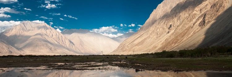
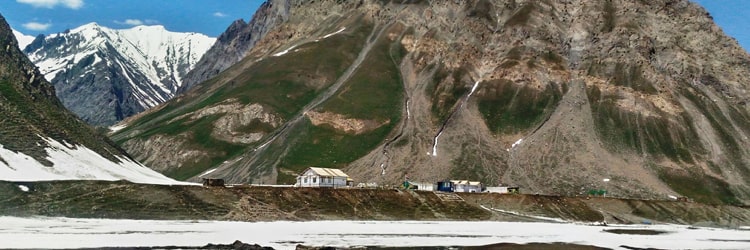
Nubra Valley lies about 150 km north of Leh where the rivers, Shyok and Siachan, meet form a large valley. This valley separates the Ladakh from the Karakoram Ranges and the famous Siachen Glacier lies to the north of the valley. To the northwest of Nubra valley, lies The Sasser Pass and the famous Karakoram Pass of the 'Silk Route' fame which connect Nubra with Xinjiang. Panamik village is the last settlement in the northern end of in Nubra valley is open to tourists. Nubra valley has a lot to offer and is as a must do for everyone who travels to Leh It has been identified as a tourist circuit by the local administration of Leh district.
Kargil is a town, which serves as the headquarters of Kargil district of Ladakh in the state of Jammu and Kashmir in India. It is the second largest town in Ladakh after Leh. It is located 60 km and 204 km from Drass and Srinagar to the west respectively, 234 km from Leh to the east, 240 km from Padum to the southeast and 1,047 km from Delhi to the south.
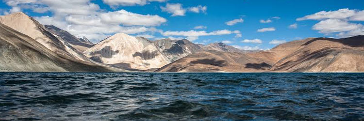
Pangong Tso or Pangong Lake is an endorheic lake in the Himalayas situated at a height of about 4,350 m (14,270 ft). It is 134 km (83 mi) long and extends from India to the Tibetan Autonomous Region, China. Approximately 60% of the length of the lake lies within the Tibetan Autonomous Region. The lake is 5 km (3.1 mi) wide at its broadest point. All together it covers 604 km. During winter the lake freezes completely, despite being saline water. It is not a part of the Indus river basin area and geographically a separate landlocked river basin. The lake is in the process of being identified under the Ramsar Convention as a wetland of international importance. This will be the first trans-boundary wetland in South Asia under the convention.
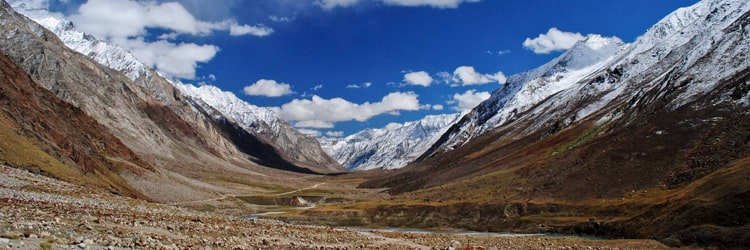
About 20 kms south-east of Rangdum stands the Panzila axis, across which lies Zanskar, the most isolated of all the trans-Himalayan valleys. The Penzila pass (4,401m) is a picturesque tableland surrounded by snow-covered peaks. As the Zanskar road winds down the steep slopes of Penzi-la to the head of the Stod valley, the majestic " Drang-Drung" glacier looms into full view. A long and winding river of ice and snow, "Drang-Drung" is perhaps the largest glacier in Ladakh, outside the Siachen formation. It is from the cliff-like snout of this extensive glacier that the Stod or Doda tributary of the Zanskar River rises. The spectacular Himalayan landscape and the lifestyles of the inhabitants attract many tourists to the hidden kingdom of Zanskar. The Zanskar valley is situated across the Suru Valley and over the Pensi La in the Ladakh region of Jammu and Kashmir. Zanskar is situated 235 km away from Kargil.
Leh the erstwhile capital of the kingdom of Ladakh is now a dream destination of many and the Mecca of adventure enthusiasts! Leh, one of the coldest deserts in the world is located at a distance of 434 Kms from Srinagar and 474 Kms from Manali (Himachal Pradesh). At the time of reorganization of districts in 1979, Ladakh was divided into Leh and Kargil and now Leh district is synonymous with Ladakh and vice-versa! Built by the Buddhist kings of Ladakh in 1553 the Leh Palace was once the world's highest building. The primary attraction within the Leh city this palace is structurally similar to the Potala Palace in Lhasa. Now only the palace prayer room lives up to the sense of former grandeur of Leh Palace. Leh is a backpacker's haven with numerous trekking trails, valleys, and picturesque lakes.
Drass (3230 m), 60 km west of Kargil on the road to Srinagar, is a small township lying in the centre of the valley of the same name. It has become famous as the second coldest inhabited place in the world by virtue of the intense cold that descends upon the valley along with repeated snowfalls during winters. Winter temperature is sometimes known to plummet to less than minus 40 degrees. The Drass valley starts from the base of the Zojila pass, the Himalayan gateway to Ladakh. For centuries its inhabitants are known to have negotiated this formidable pass even during the most risky period in the late autumn or early spring, when the whole sector remains snow-bound and is subject to frequent snow storms, to transport trader's merchandise across and to help stranded travellers to traverse it. By virtue of their mastery over the pass they had established a monopoly over the carrying trade during the heydays of the Pan-Asian trade. A hardly people enduring with fortitude and harshness of the valley's winter, the inhabitants of Drass can well be described as the guardian's of Ladakh's gateway. Drass is a convenient base for a 3-day long trek to Suru valley across the sub-range separating the two valleys. This trek passes through some of the most beautiful upland villages and flower sprinkled meadows on both sides of the 4500 mts high Umbala pass, which falls enroute. The trek to the holy cave of Amarnath in neighbouring Kashmir, which stars from Minamarg below Zojila, takes 3 days and involves crossing of 5200 mts high pass. Drass also offers numerous shorter treks and hikes to the upland villages.
After Indian Independence, a Union Territory of Hill states was created. It primarily consituted of hill states around Shimla. On November 1, 1966 Punjab Hill areas were merged into Himachal as part of reorganization of Punjab. Himachal Pradesh became a full fledged state of the Republic of India on January 25, 1971. Himachal Pradesh has been on the path of progress since Independence. The literacy rate of the state is 63% now and is improving every decade. The population has almost stabilized at about 5 million, thanks to high literacy and effective family planning programs. Every village in the state has electricity and drinking water now. Many young men from Himachal serve the Indian Army and have played significant role in the National defense. Dharamsala has a war memorial dedicated to the memory of those who lost their lives for their country. Himachal has one state university at Shimla, namely, Himachal Pradesh University. There is a Regional Engineering College (REC) at Hamirpur that has students from all over India. In addition, there is a Medical College at Shimla.Himachal is literally a power house when it comes to hydro-electricity. The state has many dams that harness the hilly rivers to generate electric power. The electricity is used by farmers in Punjab, Haryana and by the industries in the northern plains.
Kullu in Himachal Pradesh is one of the most frequented tourist destinations. Often heard along with the name Manali, yet another famous tourist spot, Kullu is situated on the banks of Beas River. It was earlier called as Kulanthpitha, meaning 'The end of the habitable world'. Awe-inspiring, Kullu valley is also known as the 'Valley of Gods'.Nestled in the lap of the majestic Himalayas, Kullu is a veritable jewel in the crown of Himachal Pradesh. The breathtaking beauty of its marvelous landscapes, the hospitality of its people, their distinctive lifestyle and rich culture have enthralled travelers for aeons.
Manali is a high-altitude Himalayan resort town in India's northern Himachal Pradesh state. It has a reputation as a backpacking center and honeymoon destination. Set on the Beas River, it's a gateway for skiing in the Solang Valley and trekking in Parvati Valley. It's also a jumping-off point for paragliding, rafting and mountaineering in the Pir Panjal mountains, home to 4,000m-high Rohtang Pass.
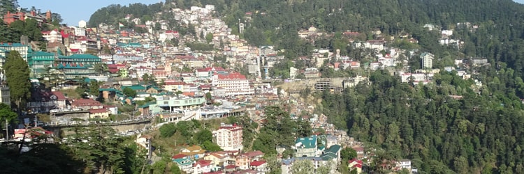
Shimla is the capital of the northern Indian state of Himachal Pradesh, in the Himalayan foothills. Once the summer capital of British India, it remains the terminus of the narrow-gauge Kalka-Shimla Railway, completed in 1903. It's also known for the handicraft shops that line The Mall, a pedestrian avenue, as well as the Lakkar Bazaar, a market specializing in wooden toys and crafts.The enchanting beauty of Shimla made British declare the land as their summer capital. The colonial influence is still evident in the city. The hill station offers spectacular views of the snow-capped Himalayan ranges. With lakes and rich greenery around, Simla welcomes tourists round the year, of course, if you don't mind the 'below zero' temperature in winter.
The High snow clad Dhauladhar ranges form a magnificent backdrop to the hill resort of Dharamsala. This is the principal township of Kangra district and overlooks wide spread of the plains. With dense pine and deodar forests, numerous streams, cool healthy air, attractive surroundings and the nearby snowline, Dharamsala has everything for a perfect holiday. It is full of life and yet peaceful. The headquarters of His Holiness the Dalai Lama are at upper Dharamsala. Covering a wide area in the form of twin settlement, lower Dharamsala (1380m) is a busy commercial centre. While upper Dharamsala (1830m) with the suburbs of Mcleodganj and Forsytheganj, retains a British flavor and colonial lifestyle. The charming church of St. John in the wilderness is situated here and this is the final resting place of Lord Elgin, a British Viceroy of India during the 19th century. There is also a large Tibetan community who have made this place their home. Numerous ancient temples like Jwalamukhi, Brijeshwari and Chamunda lie on the plains below Dharamsala.
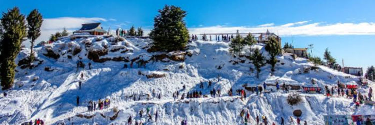
Kufri is a small hill station in Shimla district of Himachal Pradesh state in India. It is located 20 km from the state capital Shimla on the National Highway No.22. Kufri with NH-22, Shimla district. The name Kufri is derived from the word kufr meaning "lake" in the local language. Bear in the Kufri zoo. The highest point in the surrounding region, Kufri has a Himalayan wildlife zoo which hosts rare antelopes, felines and birds including the Himalayan monal, the state bird of Himachal Pradesh until 2007. During winter a meandering path through the potato plantations turns into a popular ski track.

In western Himachal Pradesh, the hill station of Dalhousie is full of old world charm and holds lingering echos of the Raj era. It covers an area of 14 sq. km. and is built on five hills - Kathlog, Patreyn, Tehra, Bakrota and Balun. It is named after the British governor General of the 19th century, Lord Dalhousie. The town's average height is 2036 m, and is surrounded by varied vegetation - pines, deodars, oaks and flowering rhododendron. Dalhousie has charming colonial architecture, including some beautiful churches. Its location presents panoramic views of the plains and like a long silver line, the river Ravi twists and turns below Dalhousie. The spectacular snow-covered Dhauladhar mountains are also visible form this enchanting town.
Chamba is bounded on north-west by Jammu and Kashmir, on the north-east and east by Ladakh area of Jammu and Kashmir state and Lahaul and Bara-Bangal area of Himachal Pradesh, on the south-east and south by the District Kangra of Himachal Pradesh and Gurdaspur District of the Punjab.Ensconced in the valley of the fast-flowing Ravi River, the capital of Chamba district is a beguiling old town with some beautiful temples, a good museum and bustling markets. Chamba was founded in AD 920 when Raja Sahil Varman moved his capital here from Bharmour, and it remained capital of the Chamba kingdom until merger with India in 1947, though under British control from 1846.
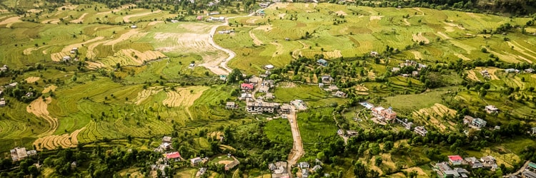
Known as one of the most picturesque valleys of lower Himalayas, the Kangra valley is full of greenery and provides a tremendous contrast in nature of places to be visited. The region is famous for the arts and crafts. Crafts like the exquisitely designed shawls and miniature paintings of this region are internationally appreciated.Guest houses located in Kangra valley give the tourist a breathtaking view of the valley and the mountains beyond. However, these have to be booked in advance. Many hotels provide extra facilities like Ayurvedic massages, fitness centers, horse riding and swimming pools. Modern life requirements like high speed internet and television are found in most hotels. Some hotels have in-house stores that sell honey, rice, opium and other spices cultivated in Kangra.

This small hill station seems to live in time warp that belongs to the 19th century. The narrow roads of Kasauli (1951m) slither up and down the hillside and offer some magnificent vistas. Directly below is the spread of vast plains of Punjab and Haryana which as darkness falls, unroll a gorgeous carpet of twinkling lights. At 3647 m, the peak of Choor Chandni also called the Choordhar powerfully dominates the lower hills and across the undulating ranges, Shimla is visible.The upper and lower malls run through Kasauli's length and one can enjoy longs walks. A mixed forest of pine, oak and huge horse-chestnut encircles the town. Its colonial ambience is reinforced by stretch of cobbled road, quaint shops, gabled houses with charming facades and scores of neat little gardens and orchards.
Amritsar, home to the Golden Temple is one of the most ancient and fascinating cities of India. It is an important seat of Sikh history and culture. Being the gateway for travellers coming to India on the overland route from central Asia it soon became the centre of various commercial activities. There are various historical and religious sites. The most famous of them all in the Golden Temple which was founded by the fourth Guru of Sikhs, Guru Ramdas and completed by his successor Guru Arjan Dev.
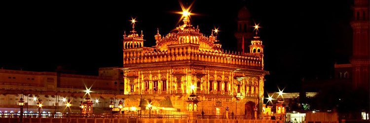
The Harimandir Sahib is considered holy by Sikhs. The holiest text of Sikhism, the Guru Granth Sahib, is always present inside the gurdwara. Its construction was mainly intended to build a place of worship for men and women from all walks of life and all religions to come and worship God equally. Over 100,000 people visit the holy shrine daily for worship. There are four doors to get into the Harmandir Sahib, which symbolize the openness of the Sikhs towards all people and religions.The present-day gurdwara was rebuilt in 1764 by Jassa Singh Ahluwalia with the help of other Sikh Misls. In the early nineteenth century, Maharaja Ranjit Singh secured the Punjab region from outside attack and covered the upper floors of the gurdwara with gold, which gives it its distinctive appearance and its English name.
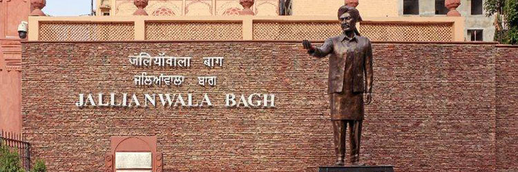
Jallianwala Bagh is a public garden in Amritsar in the Punjab state of India, and houses a memorial of national importance, established in 1951 by the Government of India, to commemorate the massacre by British occupying forces of peaceful celebrators including unarmed women and children, on the occasion of the Punjabi New Year on April 13, 1919 in the Jallianwala Bagh Massacre. Colonial British Raj sources identified 379 fatalities and estimated about 1100 wounded. Civil Surgeon Dr. Smith indicated that there were 1,526 casualties. The true figures of fatalities are unknown, but are likely to be many times higher than the official figure of 379.The 6.5-acre garden site of the massacre is located in the vicinity of Golden Temple complex, the holiest shrine of Sikhism.The memorial is managed by the Jallianwala Bagh National Memorial Trust, which was established as per the Jallianwala Bagh National Memorial Act passed by the Government of India in 1951.
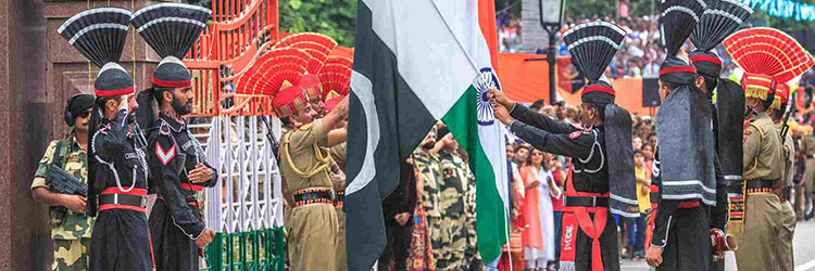
Wagah, named Wahga in Pakistan, is a village near which the accepted Radcliffe Line, the boundary demarcation line dividing India and Pakistan upon the Partition of India, was drawn. The village lies 600 meters west of the Border line. At the time of independence in 1947, the migrants from the Indian parts of the subcontinent entered the present day Pakistan through this border crossing. The Wahga railway station lies 400 meters to the south and only 100 meters from the Border line itself. In Pakistan the Border crossing is known as Wahga Border whereas in India it is called Atari Border crossing, named after the Indian village Atari, which lies 500 meters east of the border line within Indian territory.
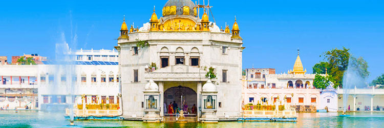
The Durgiana Temple also known as Lakshmi Narayan Temple, Durga Tirath and Sitla Mandir, is a premier temple situated in the city of Amritsar, Punjab, India. Though a Hindu temple, its architecture is similar to the Golden Temple. This temple derives its name from the Goddess Durga, the chief Goddess deified and worshipped here. Idols of Goddess Laksmi (goddess of wealth) and Vishnu (the protector of the world) are also deified here and worshipped.
Situated on the Batala Road in Amritsar, Sun City Water Park is one is one of the most popular and visited water parks in the city. Replete with a plethora of water rides, regular rides, aqua dancing, roller coasters, several swimming pools, the water is the ideal hangout destination among both the adults and the kids.

Sadda Pind is a Punjabi Village resort spread across 12 acres of land. It brings you a chance to experience authentic culture, colours and flavours of Punjab in one place. Situated in the holy city of Amritsar, just 8 kms from Golden Temple and 7 kms from airport, Sadda Pind offers a perfect setting for a weekend getaway or a short stay with family and friends.